125052
Below are the complete details of 125052 pincode area location :-
| PinCode : | 125052 |
| Area : | Kutia Kheri(28) |
| Office Name : | Ghursal B.O |
| Sub District : | Adampur |
| District : | HISAR |
| State : | HARYANA |
| Country : | INDIA |
All India Pincode Finder
PIN Code stands for Postal Index Number Code. It is also known as Zip code or postal code. It is a 6 digit code of Indian Post Office numbering code system which is used by postal service of India i.e., India Post. The PIN Code system was first introduced on 15th August 1972, by Shriram Bhikaji Velankar, an additional secretary in the Government of India’s Ministry of Communications.
India is a country with vast geographical area consisting of so many states, districts, cities, towns, mandals and villages. Inorder to find the right person or a particular place is a bit challenging for the Postal Service of India. So to overcome this situation, the postal service of India i.e., India Post has introduced a six digit PIN Code number system inorder to make the process of delivering parcels or letters in a more effective way.
This PIN Code system was introduced to simplify the process of sorting and delivering the mails manually, inorder to eliminate confusion between incorrect addresses, similar place names or area names, and different languages used by the different people. This PIN Code system follows a standard procedure that helps in simplifying the process of delivering the mails, parcels or letters in a effective way.
PIN Code structure :-
The postal service of India has categorised this PIN Code system into 9 postal zones i.ei, 1 to 9 digits from number system. In this 6 digit PIN Code system, the first digit of pincode has been assigned by these 1 to 9 digits from number system. In this 1 to 8 digits are allocated to 8 different geographical regions or zones and 9 digit is reserved for Indian Army region or zone.
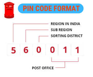
The format or structure of 6 digit PIN Code system which is designed by postal service of India i.e., India Post is shown below :-
The first digit represents a particular region or zone.
The 2 digit represents the sub region or sub zone of the postal circles.
The 3 digit represents a sorting district within that region or zone.
The last 3 digits together represents to delivery Post Office within the sorting district.
PIN Code Delivery system :-
Each PIN Code is assigned to one delivery post office, which receives all the mails to be delivered to various post offices within its jurisdiction. The delivery post office can be the General Post Office(GPO), a head office(HO) or a sub-office(SO) which is situated in urban areas. From these offices, the mails are sorted and routed to their relevant sub-offices or branch offices of the same PIN Code. Then finally delivers all the mails to the correct addresses or recipients with the help of a postman.


